Crossing Jewfish Creek marks the official transition from Mainland Florida to the Florida Keys. It lies at the end of the infamous 18-Mile Stretch, the part of US 1 where perfectly nice people lose their minds and drive as if they are the only person on the planet who wants to get to the Keys (or needs to get home from the Keys). Since Henry Flagler completed the Overseas Highway in 1910, we’ve all been trying to be in the same place at the same time on that road! At any rate, we almost always open the windows as we cross the Jewfish Creek bridge so we can get a breath of fresh Keys air. I recently learned that the distinctive shade of blue used for the median barriers is called Belize Blue.

Note: There’s another way, though! If you take Card Sound Road (a left turn off US 1 in Florida City), you will pass through miles of wilderness before reconnecting with US 1 on Key Largo. There’s a toll which varies by payment method, but I think the buck and a half via SunPass is worth it — you decide for yourself. This route takes a few minutes longer, but I find it infinitely more relaxing. There’s a famous joint called Alabama Jack’s…we have never stopped there but it’s highly recommended by those who have. If you bypass Alabama Jack’s, you’ll soon find yourself crossing Card Sound, and I’m going to bet you’ll gasp at the beauty of the water. If not there, then along one of the next bridges you cross.
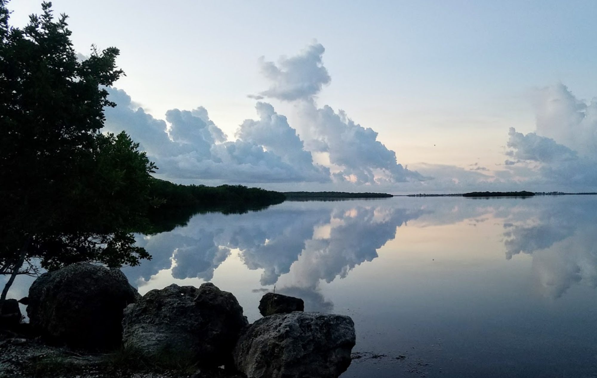
Whichever way you get to Key Largo, now you are heading south with the Atlantic Ocean on your left and Florida Bay and the Gulf of Mexico on your right. The Upper Keys are made up of Key Largo Limestone, the fossilized remains of a prehistoric coral reef. You may notice a green iguana or two (they’re invasive) munching on plants along the road. You’ll see familiar trees like pines and oaks, but the farther into the Keys you get, the more those will be replaced by Gumbo Limbo, Jamaican dogwood, and even mahogany. The tourist season falls from November through April, with the hot and wet season running from May to October. Even when it is steamy hot and muggy, the Keys are gorgeous and if you haven’t seen them yet, get down there before sea level rise removes them from our maps.
On Key Largo, you will find John Pennekamp Coral Reef State Park. Here, you will find glass-bottom boat tours, hiking along a mangrove trail, and water sports of many kinds. Snorkel and scuba trips can be booked at the park concession. The mangrove trail is closed due to Hurricane Irma — yes, nearly two years later and the Keys have not yet fully recovered. If you enjoy camping, you’ll need to make your reservations nearly a year in advance — the park fills quickly, but it’s worth the effort to camp in the Keys. If you can survive the no-see-ums (which you can, with a bit of planning), you’ll sleep soundly and wake to the best days ever.
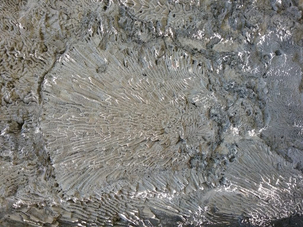
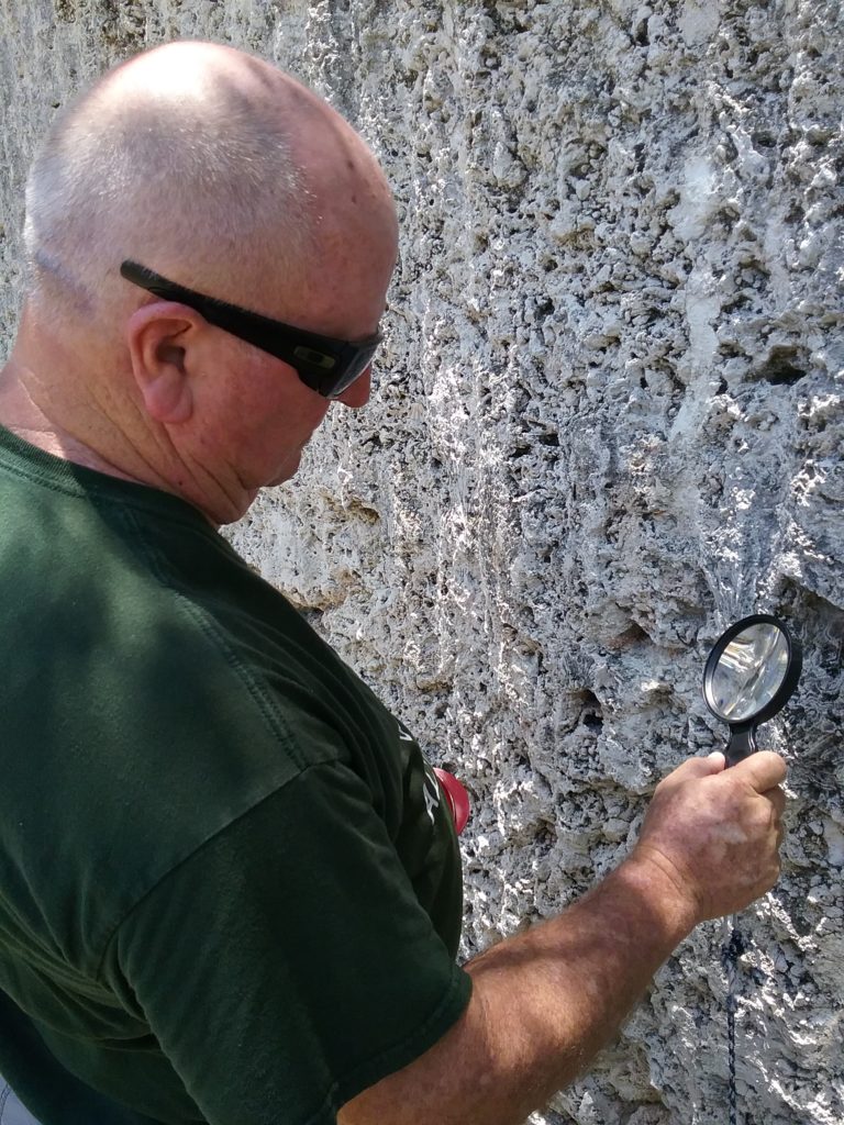
You’ll find yourself in Islamorada before you know it. This is not a single island, but a group of islands. The really pretty water begins here. You’ll notice shades of teal and turquoise that you’ve never seen before. If you have a couple of hours to spare, don’t miss Windley Key Fossil Reef Geological State Park at about Mile Marker 85 (on the right as you are heading toward Key West). If you have any doubt that the Upper Keys are made of Key Largo Limestone, this site will convince you, as you can actually hike into the quarry where stone was cut to build the railroad and other Keys structures. There are a number of trails and you can borrow a guide from the Rangers. The guides point out interesting features and highlight many different plants in the park. At some times of the year, the Rangers offer guided tours, but we found the tour guide to be excellent, and we bought a copy for ourselves. The Ranger Station has a good variety of exhibits explaining the history of Windley Key.
You’ll also see Anne’s Beach, on the left. This is a popular beach, and is dog friendly. Unfortunately, it is also under re-construction due to the hurricane, but it looks like it’s getting close to completion. I sure hope so! I’ve seen tons of goby fish here. It is an odd little beach — part sand, part mud — and entirely charming. I would go there every day if I could.
Indian Key and Lignumvitae Key, both State Parks, are also in Islamorada, but you can only reach them by boat. If you’d like to rent a kayak, they are close enough to be an easy paddle, but be sure to take plenty of water, sunscreen and bug spray! We were not able to get to these parks in June, but when we come back in the fall they are our priority to visit. Indian Key was once the county seat of Dade County! Lignumvitae Key is a tropical hardwood hammock, and I’ve heard that the mangrove creeks are unparalleled for beauty.
As you continue down U.S. 1, you’ll come upon Marathon, the middle of the Keys. This highly populated island is home to Sombrero Beach. This is a sandy beach, highly unusual for the Keys. It is nicely appointed with bathhouses and picnic tables, many of which are shaded. Part of the beach is rocky, so wear good water shoes. Watch for curly-tailed lizards! On our next trip, we plan to visit Crane Point Museum, which we’ve promised ourselves to visit for years.
At the bottom of Marathon is one of the wonders of the Southern United States. The Seven-Mile Bridge is the longest in the state. It took divers, barges, steamships, dredges and a crew of civil engineers to build the original railroad bridge, and it took them over 10 years to do it. The original bridge is still visible as you cross on the new bridge. You’ll notice Pigeon Key where the workers lived. There is a tour of this small island which is supposed to be great — I hope we can take the tour soon! The bridge was completed in 1916, but the Labor Day hurricane of 1935 blew trains off their track and snapped palm trees like carrot sticks. The bridge was sold to the US government and eventually rebuilt for car traffic. Today, the original bridge has been closed to the pedestrian traffic that had been using it while it undergoes extensive repair funded by FDOT.
Now you are entering what I consider the most beautiful easily accessible place on earth – the Lower Keys. Get ready to be blown away by the colors, experiences, and adventures you are going to encounter here.
Bahia Honda State Park offers beautiful beach camping as well as fully appointed cabins. There are two sandy beaches, a bit of hiking, and a nice concession. When Steve and I first visited this park, it displaced Alexander Springs as my favorite spot on earth (and that was no small feat). You can see the old railroad bridge. You can also see “Little Bahia Honda” which used to be a lush mangrove island on the Atlantic side. Now it is dead, another casualty of Hurricane Irma.
Big Pine Key is next, and a couple of things are interesting about this part of the map. First, the islands are now made of Miami Limestone, and second, because of the way the currents push, you’ll notice that rather than running generally east to west, the land is now running north to south, and the road runs almost due west (rather than north to south). The water surrounding the lower keys is shallow for long distances. This creates unbelievable watercolor seascapes and endless opportunities for wading, snorkeling, kayaking and paddleboarding. I could look at this water all day long. Especially if there’s a breeze and a pitcher of margaritas on hand.
Big Pine Key is home to the National Key Deer Refuge and the Great White Heron National Wildlife Refuge. These are backcountry refuges comprising the islands north of Bahia Honda across to islands north of Key West. The kayaking in these refuges is amazing – we have seen nurse sharks, reef sharks, rays, and even an octopus here. I can’t think of a better place to be on the water, and for me, there is no need to travel further. Big Pine Key is as perfect as it gets in my book. There are miles and miles of trails to hike in the Great White Heron Refuge. Blue Hole, an old limestone quarry that has filled with fresh water, is home to an alligator or two and has decks for wildlife watching. At the grocery store, there are always chickens and Key Deer in the parking lot. The water is lovely and there are many places to launch a kayak. The island has all the modern conveniences but manages to maintain a really rural feel. The next time we travel to the Keys, I’ll take more notes on the islands beyond Big Pine, but it’s this big island that has truly captured my heart, so for now, this is where we’ll sit.